 Filter: Categories of Wisconsin Historical Images
Filter: FORMAT_DIMENSIONS of 46 x 44 cm
Filter: Categories of Wisconsin Historical Images
Filter: FORMAT_DIMENSIONS of 46 x 44 cm

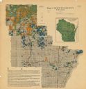
| Date: | 1858 |
|---|---|
| Description: | A survey map that shows the status of township surveys in Wisconsin. At that point, the majority of the state had been surveyed and platted, with the area... |
| Date: | 1920 |
|---|---|
| Description: | This map shows the township and range system, sections, cities and villages, railroads, roads, and streams and lakes in Oconto County, Wisconsin. Color co... |
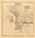
| Date: | 1920 |
|---|---|
| Description: | This map shows zoning in the city of Stevens Point. Streets are labeled and the upper right hand corner features a "Legend & Summary Of Zoning Regulations"... |
If you didn't find the material you searched for, our Library Reference Staff can help.
Call our reference desk at 608-264-6535 or email us at: